A hiker’s paradise, Los Osos lies in a valley at the edge of the Pacific Ocean. A hike on the coast might cross a mix of rugged bluffs, sand dunes, a calm estuary or mountains that peak above the fog line. Just inland, find trails that lead beneath canopies of native oak trees.
Due to coastal influence, the climate in Los Osos is temperate, with highs between 63 degrees F and 70 degrees F year-round. In other words, you couldn’t find a more comfortable destination for a hike.
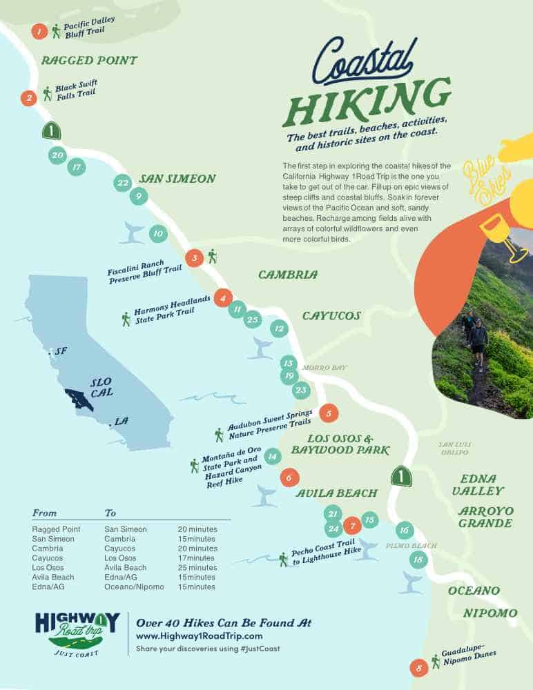
See hiking options and trails below.
Explore Los Osos Hiking
Hiking Montaña de Oro
Hiking doesn’t get much better than at Montaña de Oro State Park. Trails of all lengths and difficulty span beaches, creeks, mountains and bluffs. Just remember: dogs aren’t allowed on Montaña de Oro State Park trails.
Bluff Trail
Winding past rugged shoreline and tide pools, this trail reflects the best of Montaña de Oro State Park hiking. The trail encompasses 3.4 miles, out and back, beginning near Spooner Ranch House and the visitor center. Marvel at untouched California views of the bay and Morro Rock. One half-mile after crossing the first footbridge, enjoy Corallina Cove, or continue on for primitive trail hiking to Quarry Cove.
Valencia Peak Trail
This high-climbing trail summits 1,275 feet in 4.5 miles, roundtrip. Valencia Peak is one of the tallest for Montaña de Oro hiking. Start your walk just beyond Spooner’s Cove in the parking area across from the Bluff Trail trailhead. The Valencia Peak Trail passes through wild sage, switches back repeatedly, and covers some steep gains. An inviting picnic table at the top offers sprawling views of the coastline, from Point Buchon to Morro Rock and beyond. Note: This trail is largely uncovered by trees or vegetation; sunscreen, hats, and other coverings should be work accordingly.
Hazard Peak Trail
This 6-mile round-trip trail is known for its panoramic views of the bay and beyond. At 1,076 feet, Hazard Peak demands some steep hiking, with a total gain of 950 feet. Enjoy the aroma of sagebrush when the sun heats it, as well as the silken trunks of eucalyptus. Benches and a picnic table sit at the peak, making the most of full ocean views. The trailhead can be accessed just after the state park entrance, on the left, before Spooner’s Cove on the right.
Hazard Reef Trail
At 0.9 miles, this trail makes for an easy walk with little ones or those for whom a long hike is difficult. This trail is a loop, winding past wild flowers in season, and ending at a bluff. Scramble down to find a quiet reef and some of Montaña de Oro’s best tide pools. Explore and relax on the beach; horses are also welcome on the trail.
Islay Creek Trail
Beloved for its canyon, waterfall, and views, the Islay Creek Trail spans 6 miles, round trip, with an elevation gain of 300 feet. The trail begins where a stream terminates into Spooner’s Cove. The dirt trail winds inland from there, past the Islay Creek Campground. The trail offers terrific views of Hazard Peak and Valencia Peak. The waterfall sends water along Islay Creek, 1.4 miles in from the trailhead. At the 3-mile mark, find an abandoned barn; turn there for the 6-mile full hike.
Oats Peak Trail
While other trails offer sweeping views of the Pacific, Oats Peak has the best view of the Irish Hills to the east. Oats Peak is 1,373 feet tall, with a trail of switchbacks that gains 1,325 feet in 10.8 miles, round trip. The trailhead lies behind the Spooner Ranch House, by the road to the Islay Creek Campground. Look for signs for Reservoir Flats Trail and Oats Peak Trail. The trail is well-marked but don’t let the signs for the “Old Oaks Peak Trail” confuse you. Stay on the New Oats Peak Trail for the complete trail. Shade-dappled pullouts, a seasonal stream, and coastal vistas make this hike a must. The last bit is steep, but views of Morro Rock and the coastline beyond make the last haul worthwhile.
Reservoir Flats Trail
Easy and rewarding, the Reservoir Flats Trail begins between the Islay Creek Campground entrance and the Spooner Ranch House. Bear left at 0.3 miles where the path crosses the Oats Peak Trail. The trail gets its name from the Spooner family’s reservoir, now empty, that serves as part of the path. Cottonwood and oak trees canopy much of the loop, which clocks in at 2 miles and a 200-foot elevation gain. Finish at the trailhead, beside the Islay Creek Campground.
Coon Creek Trail
At the south end of Montaña de Oro, this trail winds through a canyon to a stand of Monterey cypress trees and back again. The total distance for this trail is 5 miles round-trip, and elevation gain is just 250 feet. Watch for junctions with the Oats Peak Trail and Rattlesnake Flats Trail. The trailhead can be found just off a parking area at the far end of Pecho Valley Road. (This is also where to park for the Point Buchon Trail.) Find the sign marker for the single-track dirt path and follow it inland. Soon, the trail will enter a canyon, skirting a picnic table; in spring, lush views of wildflowers abound. Walk over two footbridges within the first mile, with four more along the trail. Look for wider views at about 1.25 miles, where the path intersects with the Rattlesnake Flats Trail. At about 2 miles, find a giant oak tree, lovingly called the Mother Oak. The grove of Monterey cypress trees lies just beyond, with a sign explaining that the grove once shaded a homesite older than Spooner Ranch.
Morro Bay Sandspit Trail
For a long, minimally trafficked shoreline walk, try the Morro Bay Sand Spit Trail. At 10.2 miles total, this out-and-back trail gains just 465 in elevation, but provides an endurance challenge in distance. The walk starts among sand dunes and follows the long spit that connects the towns of Morro Bay and Los Osos. Walking north, the Estero Bay is to the left, and the estuary is to the right. Treat yourself to unbroken ocean vistas and a killer view of Morro Rock. Depending on the season, the hike can also include wildflowers like lupine and evening primrose, as well as heather, coyote bush and salt grass. Find clamshells, sand dollars and Chumash middens (ancient trash heaps) along the way. To locate the trailhead, turn right into the Sandspit day-use area and park at the end of the road. Take a short trail to the beach and head north along the spit, all the way to the end (just across from Morro Rock) and back. Note: this is a long walk with no facilities (e.g. restrooms, water, dining), so plan accordingly.
Hiking Oaks Natural Reserve
Ninety acres of ancient oaks make up the Los Osos Oaks State Natural Reserve, which welcomes hikers to three internal trails. Many of the oaks are 800 or more years old, with gnarled roots and splaying branches. The entrance to the reserve stands at 1813 Los Osos Valley Road, just east of Los Osos. Park in the parking area and follow trail markers into the grove.
Chumash Trail
Pass through the center of the oak grove on this trail along the western edge of the reserve. Large branches straddle the path, making for a fun obstacle along the way.
Los Osos Creek Trail
Traveling eastward, the Los Osos Creek Trail is named after the seasonal stream it passes.
Oak View Trail
Looping southward, this path crosses beneath a canopy of oaks and beside native chaparral.
#WildlyAdventurous
Hiking Point Buchon Trail
Looking for untouched, remote beauty? This moderate 6.6-mile round-trip trail begins in Montaña de Oro State Park and travels into the northern edge of PG&E property. Along the way, look for wildlife along the bluffs: golden eagles, badgers, bobcats, coyotes and peregrine falcons. Also visible from the trail, tidepools provide a home for nearshore marine species. In spring, look for exuberant wildflowers, as well as migrating grey whales. Be aware that the Point Buchon Trail includes narrow paths, steep stretches, prickly thistles and shifting earth. Rattlesnakes and ticks should also be considered. The trail is open Thursday through Monday, all year except for major holidays, and is limited to 275 hikers per day. Summer hours are 8 A.M. to 5 P.M. and winter hours are 8 A.M. to 4 P.M. To reach the trailhead, drive to the far end of Montaña de Oro and park in the Coon Creek parking lot. Check in with the trail attendant there to sign a waiver and register for the hike.
Hiking Sweet Springs Nature Preserve
The Audubon Sweet Springs Nature Preserve offers 24 acres of trails and panoramic views of the Estero Bay. The nature preserve is managed by the Morro Coast Audubon Society and boasts trails that weave among trees like stately Monterey cypress and dramatic eucalyptus. The preserve also includes two freshwater ponds and is framed by a salt marsh. See threatened and endangered shorebirds, as well as Monarch butterflies from October to March. From Highway 1 (north or south), take exit 227 south toward Los Osos/Baywood Park. Continue on South Bay Boulevard for 2.5 miles and turn right on Santa Ysabel Avenue. Turn left on Seventh Street, right on Ramona Avenue, and continue on Ramona for 3 blocks to the corner of Fourth Street. Note: pets are not allowed in the Sweet Springs Nature Preserve.